Denver’s population is just over 700,000. More than 100,000 people have moved to the city in the last seven years alone. With increasing job opportunities, a vibrant community, and diverse neighborhoods, the Mile High City has bloomed into an attractive urban destination.
To accommodate the influx of new residents and public transit riders, the city and the Regional Transportation District are working to keep up with demand. This year, FUSE fellow Chris Dishno, is helping both agencies create a process to work better together, with the ultimate goal of improving transit service and reliability for residents, employees, and visitors. During his fellowship, he’s helping to implement the Denver Moves Transit plan, even before the plan is completely final, by establishing and documenting new processes to push projects from pipeline into implementation.
The goal: to improve coordination between RTD and the city’s Department of Public Works, and coordinating the process by which the two agencies track their projects can have outsize impact on speed and efficiency. With 888 employees at RTD who directly work with Public Works, and 1400 Public Works employees, coordination amongst the agencies is critical.
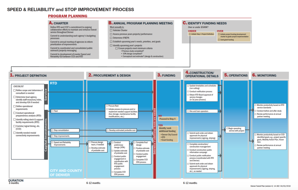
To help build coordination and collaboration between the agencies and employees, Dishno has created a roadmap detailing the steps necessary to complete projects. It’s a dashboard of sorts that shows different phases from each agency’s vantage point, as well as a timeline, and point of contact for who is leading the effort. The process map includes the involvement and responsibilities of each agency to keep efforts aligned and coordinated, and most importantly, keep it moving.
There are six phases in the process map:
- Project definition. This phase identifies the arc of the scope, the lead employees, operations requirements, and analysis for operational preparedness.
- Procurement and design. This phase determines different stages of the procurement process, whether certain tasks are outsourced or completed within the agency, and whether the fleet needs to grow or scale back. This answers questions like whether the agencies need to go through a procurement process to hire a designer, or whether they take on the task themselves; or whether they add more fleet or scale back.
- Funding. Agencies assess whether additional funding is needed, or the existing budget will work.
- Construction and operational details. In this phase, agency staff finalize details such as transit timetables and bus routes, the construction schedule, public notifications, and work orders for signage and striping.
- Actual operations. At this stage, the new/modified service has launched, and agency staff is ensuring that all is in working order.
- Monitoring. Once the service has begun, staff are assigned to monitoring and capturing data to compare before-and-after metrics, setting goals for productivity, and ensuring that the new service is aligned with initiatives like Vision Zero which is aimed at eliminating all traffic related fatalities to zero by 2030.
The pilot version of this roadmap was created on Adobe Illustrator, commonly used software to create illustrated charts and graphs. Dishno would like to see it developed into an online dashboard that can be updated and accessed in real time.
Process in Practice
The agencies have so far used the process map to launch a program called Transit Signal Priority (TSP), which connects buses to approaching traffic lights through modem signals, keeping the lights green for buses. The actual technology was installed nine months ago, but because of communication gaps, the service did not begin until just a few weeks ago.
The TSP project amounted to $8,500, which adds up to a tenth of a cent over a 20-year cycle. Now buses hit red lights half as often as they did before the TSP was put in place. The faster travel times draws more users to public transportation for a modest investment by the city and RTD.
The process map will also be deployed for other projects, which Dishno hopes will be launched by the end of the year. This includes the Bus Bulb project, which extends sidewalks out to eight feet at bus stops, giving busses easier access to passengers; creating bypass lanes that will allow buses to go straight, while single occupant cars turn right in a separate lane; and consolidating bus stops, which will halve the number of stops for buses.
The process map has helped create efficiency between organizations, leading to a more cohesive intracity transit system.
[Photo credit: Ricardo Gomez]